

How much wetland area has California lost?
La Cienega Wetland Complex - urbanization in Los AngelesThe Sacramento-San Joaquin Delta - agriculture and flood protection
San Pablo Bay - mining and diking
The Central Valley - floodplains into farmland
Estimates of total historical wetland loss vary for California. Some regional studies have reported loss rates up to 90% in the state. Some wetland types, such as vernal pools, riparian habitat, and coastal wetlands, have experienced disproportionately higher rates of loss. For example, an estimated 7 million acres of vernal pools existed at the time of initial Spanish exploration, of which less than 13% remains today.
Many types of land use activities can cause wetland degradation, destruction, or modification. Agricultural drainage, dewatering from groundwater withdrawals and construction of roads and rail have accounted for much of the historical wetland loss. In more recent times, urban development, infrastructure, pollution, and invasive species have contributed to wetland loss.
An understanding of historical wetland patterns and loss can help managers understand how landscapes change over time, and how natural wetlands functioned as part of larger systems. Studies done in Southern California, the San Francisco Bay, and the Sacramento-San Joaquin Delta highlight the differing degrees of impact in different regions of the state. In the Delta, perennial marshland has been particularly impacted - only 3% of historical freshwater emergent wetland remains today. In the San Francisco Bay, only 15% of historical estuarine wetlands remain. Studies in several southern California watersheds indicate between 75 and 85% of historical wetlands have been lost.
La Cienega Wetland Complex - urbanization in Los Angeles
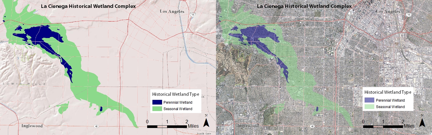
Spanish for "The Marsh", the La Cienega wetland complex once spanned over 7,000 acres and extended from present-day Hollywood to Inglewood. These former wetlands have been incorporated into the vast urbanized expanse of the Los Angeles metropolitan area. The transformation of wetlands into urban landscapes is not a phenomenon limited to Los Angeles; similar examples can be found in urban areas across the state.
The Sacramento-San Joaquin Delta - agriculture and flood protection
 (click to enlarge)
Until the mid-1800’s, the entirety of the Sacramento-San Joaquin Delta was a complex network of channels and wetlands . The historical marshes of the Delta were maintained by periodic flooding and nourished by sediments carried in by floodwaters.
Beginning around 1850, reclamation efforts began to transform the many islands of the Delta into farmland. Levees were built around the islands and the water was pumped out, allowing the fertile peat soils beneath to be farmed. In the early years, levees to protect the land from flooding were constructed by hand. By the 1870’s, steam-powered dredges were digging new channels throughout the Delta and constructing large levees with the moved earth. This process led to the transformation of the expansive Delta wetland into one of California's core agricultural regions. By the mid-1920's, virtually the entire Delta had been converted into farmland.

The San Francisco Estuary Institute (SFEI) recently completed a comprehensive historical ecology study of the Delta, and an interactive map has been published that allows for full exploration of the results.
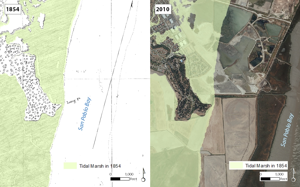
San Pablo Bay - mining and diking
 (click to enlarge)
The diked former marshes along the shores of San Pablo Bay provide an interesting example of how distant land uses can affect wetlands downstream. These two maps show the western margins of San Pablo Bay in Marin County.
Two factors explain this loss of wetlands. By the mid-1850s, hundreds of miles away in the foothills of the Sierra Nevada, hydraulic gold mining operations had begun. Water cannons obliterated hillsides in order to recover the gold deposits within. The byproducts of these operations were massive amounts of mining debris which made their way into tributaries feeding the Sacramento River and, ultimately, into San Pablo Bay and beyond. Debris deposits blanketed the margins of San Pablo Bay in a swath about a mile wide and three feet thick (Gilbert 1917).
The second factor was the successive rows of dikes that were built across the tidal marshes during the late 1800's. Today, these diked former marshes host a number of land uses including cattle grazing, agriculture, and sewage treatment. On the bay side of the dikes, new tidal marshes have begun to grow, and the present shoreline lies about a mile east of the 1854 shoreline.
Changes in wetland extent can be expected with continued land use development and climate change. The State has been working to minimize loss from ongoing development (see Wetland Protection) and has stepped up efforts to conserve and restore existing wetlands (see Efforts to Improve Wetlands).
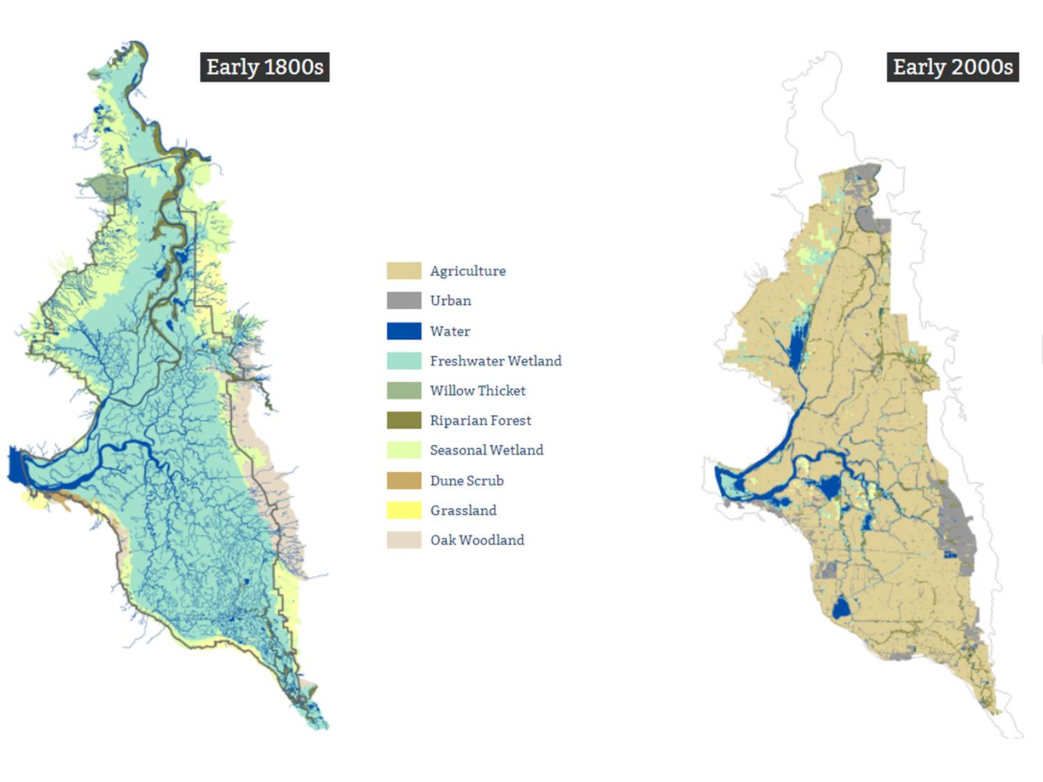
The Central Valley - floodplains into farmland
 (click to enlarge)
California's Central Valley, which now produces nearly 25% of the nation's table food on only 1% of its farmland, was once an extensive network of wetlands. Tulare Lake once had a surface area of about four times that of Lake Tahoe, while Buena Vista and Kern Lakes once held runoff from the Sierra Nevada. Expansive forests of willow, sycamore, oak, elder, poplar, and alder lined the rivers and streams that flowed into the Central Valley, and wetland grasses and tules covered the valley floors and prairies. Farmers began diking and draining the floodplains for agriculture in the mid-1800's; and, by the 1920's, about 70 percent of the original wetlands had been hydrologically modified. Nearly 4 million of the 13 million acres of the Central Valley is estimated to have been wetland before this expansive land change.
![]()
Text and graphic adapted from "Technical Aspects of Wetlands History of Wetlands in the Conterminous United States" By Thomas E. Dahl and Gregory J. Allord, U.S. Geological Survey Water-Supply Paper 2425