Where Did Our Wetland Numbers Come From?
There are a number of approaches to estimating the total wetland acreage in California. Wetland extent can be determined via standardized, comprehensive mapping, aggregating acreages from multiple datasets together, summarizing a single statewide dataset, or from estimations based on extrapolation from random sampling of wetlands maps around the state. Each method is valuable and can complement other methods, though none are perfect.
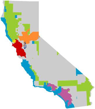
![]() The estimate we present in “How much wetland area is there in California?” (4.3 million acres) was summarized from California Aquatic Resources Inventory v.0 (CARI), a compilation of “best available” wetland datasets. By piecing together the National Hydrography Dataset (NHD), National Wetland Inventory (NWI), and high-resolution local datasets, CARI v.0 provides full coverage of wetland extent for the state. See the maps below. The dataset aggregation approach combines data with varying standards and quality. While it eliminates data gaps, meaningful comparisons between regions and wetland types become challenging.
The estimate we present in “How much wetland area is there in California?” (4.3 million acres) was summarized from California Aquatic Resources Inventory v.0 (CARI), a compilation of “best available” wetland datasets. By piecing together the National Hydrography Dataset (NHD), National Wetland Inventory (NWI), and high-resolution local datasets, CARI v.0 provides full coverage of wetland extent for the state. See the maps below. The dataset aggregation approach combines data with varying standards and quality. While it eliminates data gaps, meaningful comparisons between regions and wetland types become challenging.
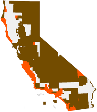
 Another recent summary of wetland extent in California reported a total of 2.9 million acres. The State of the State’s Wetlands (SOSW) report used a single dataset summary approach to calculating total extent solely based on the NWI dataset. Although the NWI is comprehensive for areas it has mapped, there are still large gaps in its coverage. Some areas therefore become underrepresented, particularly the North Coast / Klamath and the Colorado and Mojave deserts.
As statewide mapping efforts continue and higher resolution and more standardized local-scale datasets are added to CARI, the total acreage estimate of wetlands in California will change. Wetland managers are therefore discussing the “adoption” of a baseline wetland acreage that other analyses, including status and trends and net change, can be built upon. For now, the combination of NWI, NHD, and high-resolution local data, or CARI v.0, is the best approximation of wetland extent in California.
CARI v.0

| CARI v.0 MAPPING COLOR KEY | |
|---|---|
| National Wetland Inventory | |
| National Wetland Inventory - image date 2000 or later (NWI) | |
| National Hydrography Dataset (NHD) | |
| Six County Aquatic Resource Inventory | |
| Tahoe Aquatic Resource Inventory | |
| Mark West Creek Aquatic Resource Inventory | |
| Bay Area Aquatic Resource Inventory | |
| Delta Aquatic Resource Inventory | |
| Southern California Coastal Wetland Mapping Project | |
NWI

| NWI COLOR KEY | |
|---|---|
| NWI, digital data, date later than 2000 | |
| NWI, digital data, date 2000 or older | |
| Data Gaps | |

